Verona, a few kilometres from Lake Garda and easily accessible by car or train, is an ideal destination for spending a day away from the golf courses.
A brief history of Verona
The city has a thousand-year history. The foundation of a built-up area along the course of the Adige, in one of the most suitable places for crossing the river, dates back to the Neolithic period. The ancient village was probably located on Colle San Pietro along the northern bank of the Adige.
The inhabitants of Verona, Paleovenetians and Cenomani Gauls, already in the Republican era, tied themselves with bonds of friendship with the Romans. After the complete annexation of Cisalpine Gaul in 89 B.C., Verona became a Latin colony.
In 49 B.C. Julius Caesar granted Roman citizenship to the inhabitants of Verona. It is therefore in the final stages of the Roman Republican age that the city must be built, according to the typical layout of Roman centres, in the flat area inside the loop of the Adige.
In the imperial age, Verona placed at the intersection of two of the main Roman roads in northern Italy, Via Postumia, connecting the two main ports of Northern Italy Genoa and Aquileia, and via Claudia Augusta which, following the course of the Adige, led to the crossing of the Alps and the northeastern limes of the empire, it became an important commercial and military centre
Verona maintained its importance even after the end of the empire, it was the capital of the Roman-barbarian kingdom of Odoacer and then the second most important city in the reign of Theodoric.
In the early Middle Ages it changed hands in succession between the Byzantines, Lombards and Franks to then flow into the vassal territories of the Holy Roman Empire.
Like many other Italian cities in the 12th century Verona became a free Commune and then shortly after the middle of the 13th century it became a dominion controlled by Della Scala family. The Scaliger dynasty remained in power in Verona until the end of the 14th century making it an important economic, cultural and political centre. In fact, they came to control the whole of Veneto, the area of Brescia, Parma and the Tanaro valley up to Lunigiana, Garfagnana and Lucchesia.
In 1388 the city fell under the control of the Visconti of Milan and in 1405 it became part of the Republic of Venice under whose control it remained until 1796 with the intervention of Napoleon in Italy, except for a brief period between 1508 and 1516 when it temporarily came under the control of Emperor Maximilian I.
After the fall of Napoleon and the Congress of Vienna, Verona became part of the Austrian possessions in Italy and became an important fortified bulwark for the Austro-Hungarian army.
In 1866 after the III War of Independence Verona became part of the Kingdom of Italy.
A stroll in Verona
Our stroll in Verona starts from Porta Nuova station and it’ll touch only some of the many monuments that dot the city.
From the station, move towards Corso Porta Nuova, skirting the remains of one of the bastions of the southern city wall. These fortifications date back to the restructuring of the defensive system conducted in the first half of the 19th century by the Austrians who, in addition to the restructuring of the walls, built many forts and outposts around the city. The direction of the Austrian walls follows the outer city walls built during the Scaliger dominion. Indeed, Alberto I, Cangrande and Cangrande II Della Scala were responsible for the enlargement of the walls including the southern area of the city, the Veronetta area east of the river Adige and the hills north of the city. The stretch of the walls on the hills to the north, although remodelled, still remains the original construction of the fourteenth century.
Then you will find Porta Nuova, one of the city gates designed by the architect Sanmicheli and built between 1530 and 1560 in the framework of a rearrangement of the Scaliger walls made by the Venetian government to make them suitable for facing artillery fire.
Continuing along Corso Porta Nuova you reach the Portoni della Bra. We are in front of a second city wall, that of the Communal period. In this area, during the Roman period, a canal had been dug, following a depression in the ground, which at the height of the Gavi arch, where Castelvecchio would later have risen, cut the bend of the river. Along this canal which then acted as a moat, a city wall was built between the end of the 12th and beginning of the 13th century to include also those buildings at that time external to the city walls that still dated to the reign of Theodoric. In addition to the arch of the Gavi, which was incorporated into the walls as an urban gate, there were three other gates, one was later incorporated into the walls of Castelvecchio, a second one of which we have lost track and the last that was where there are now the two arches of the Portoni della Bra. This should have been a small gate protected by a tower. The opening of the two arches should date to the end of the 14th century when the Scaliger lordship fell and the city was controlled by the Visconti of Milan for a few years. In that period, a fortified wall was erected along the eastern side of today’s Corso Porta Nuova in order to create a protected area between the old Communal walls and the new Scaliger ones, to host the occupying army. Perhaps the widening of the gap in the Communal walls was functional to facilitate the entry into the city of the army of Milan in the event of a revolt by the citizens of Verona. The Communal walls have two construction phases, in fact, the first wall had been built too close to the canal and during a flood of 1239, the foundations gave way in some points causing the collapse of long sections of walls. Between 1240 and 1250 under the government of Ezzelino da Romano, a second wall was built on the more stable ground about three meters inside the previous one. These walls are the ones that are still visible today along via Pallone that goes east from Piazza Bra.
Crossing the arches you enter Piazza Bra, the parlour of Verona. This area, first outside the city, was defined as an urban space only after the 12th century with the construction of the Communal walls. Initially, it was only a dirt space designated for the timber and animal market, so much that in some documents it is called Foro Boario. In the late 16th century it began to have a more marked connotation as a square when on the western side started the construction of numerous palaces with arcades. But it was only in the eighteenth century, with the flooring of the “Liston”, that the square became the main meeting place for the people of Verona, we would now say the centre of the nightlife.
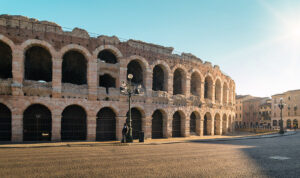 On the northern side of Piazza Bra, you can see the Arena of Verona a Roman amphitheatre built between the end of the reign of Augustus and the beginning of that of Claudius outside the city, about seventy meters from the Roman city walls. The Roman fortified urban layout of Verona must be attributed to the late Republican period, probably after obtaining the status of municipium of 49 B.C. That was a fairly convulsive period in Roman history and the construction of an amphitheatre was probably not considered necessary. A need that instead could have been more felt in a period of peace: and this goes well with the dating of the Arena of Verona in the first three decades of the first century A.D. In those years the city had reached a large number of inhabitants, making it impossible to build them inside the walls. In the following years, the proximity of a building that overlooked the height of the walls was a cause of concern for those who wanted to defend themselves in the city. So much so that when in 69 A.D. Vespasiano, fighting with Vitellio for the control of the empire, decided to position himself in Verona found himself forced to build a further defensive wall well beyond the Arena by opening the channel called Adigetto which in the Communal era would become the moat along which the walls.
Then Emperor Gallienus in 265, given the threat of the Alemanni and the importance that Verona had in the Roman road system, found himself forced to undergo a major restoration of the walls and an enlargement of about 600 meters such as to also include the Arena in the defensive system. Remains of this addition are visible in Piazzetta Mura di Gallienus on the north-eastern side of the amphitheatre. On that occasion, Gallienus also fortified the area north of the Adige near the theatre to protect the two bridges that crossed the river at the time.
If the interior of the Arena of Verona has been well preserved, the same cannot be said of the external facade of which, of the original 72, only a small part consisting of 4 arches has been preserved, in three overlapping orders. In all likelihood, various events led to the disappearance of the outer ring. In the Roman barbaric era, the building, having lost its playful function, was lowered so as not to overpower the walls and used as a quarry. Proof of this is the discovery of a fragment showing the sector number LXIII inside the remains of the walls that Theodoric had built, at the beginning of the 6th century, flanked externally to the old walls restored and enlarged by Gallienus, old walls that on the same occasion was raised. Although in the drawing depicting the city of Verona contained in the Raterian iconography, an eighteenth-century copy of a medieval code that was then lost, dating back to Raterio, who was bishop of Verona from 932 to 968, the Arena is represented as still intact. However, it could be an ideal reconstruction. But the worst blow was with the 1117 earthquake which caused extensive damage throughout the city.
Although during the Middle Ages the cavea was still used for some playful events but also for bloody events, such as public executions, it was above all a quarry of stone material for the construction or restoration of city buildings. But already under the Scaligeri, and then during the Venetian government, people began to be aware of the importance of the monument, either for its historical value or because it was considered a city symbol. The Scaliger and Venetian statutes include articles drawn up for the defence and maintenance of the monument.
from the 15th to the 18th century, the Arena became a topic of study and rediscovery and consequently, restoration and restoration interventions of the structure and tiers were organized. It became a place of knightly jousting, of theatrical performances until it was consecrated in the twentieth century as the largest open-air opera house in the world.
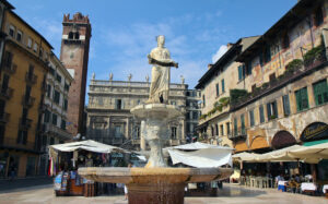 From Piazza Bra, along Via Mazzini which is the shopping street of Verona, you reach Piazza delle Erbe, which follows the ancient Roman forum of the city. The short northern side is closed by the late Renaissance Palazzo Maffei which stands on the foundations of the ancient Roman Capitol. On the western side is the medieval Domus Mercatorum seat of the city Arts and Corporations. The first building was built in wood in 1210, it was rebuilt in masonry in 1301. During its history the building underwent various modifications, the current appearance is due to renovations of the twentieth century. Along the eastern side of the square near the Maffei palace, there are the Mazzanti houses. This series of buildings, built in medieval times, was inhabited in the ‘200 by Della Scala family. Around 1540 the facades were frescoed by the painter Alberto Cavalli pupil of Giulio Romano, with whom he collaborated in the frescoes of Palazzo Te in Mantua. On this side of the square stands also the Palazzo della Ragione or Palazzo del Comune with the high Lamberti Tower. This complex, born as a private fortified palace, was acquired by the city administration as the seat of government during the 12th century. After 1405 with Venetian control, it became the courthouse of Verona. Recently restored, it is the seat of the Gallery of Modern Art in Verona. In the square, there is a fountain, built in 1368 by Cansignorio della Scala with recycled Roman materials. This fountain carries a statue on the top, called the Madonna of Verona, composed of a Roman body, most likely coming from the remains of the Capitol, to which new arms and heads were added.
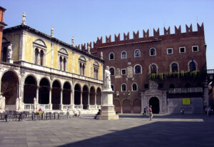 From Piazza delle Erbe, passing under the Arco della Costa, so-called for the whale rib that has been hanging there since the mid-18th century, you pass into Piazza dei Signori. If Piazza delle Erbe from the Middle Ages onwards was considered the centre of the economic and commercial life of Verona, Piazza dei Signori, built in the period of the Scaligera lordship, can be defined as the centre of political power. Some of the most important administrative buildings overlook this square. The Palazzo della Ragione, a symbol of power during the municipal era, the Palazzo del Podestà and the Palazzo del Capitanio built by the Scaligeri in the 13th and 14th centuries, and the Council loggia built in the late 15th century to host the meetings of the Patrio Consiglio (the Town Parliament). The Palazzo del Podestà owes its name to the fact that during the Venetian era it hosted the representative of the Serenissima Republic. This palace was restored to its original appearance with restorations in the 20th century while retaining the Renaissance door designed by architect Sanmicheli. The Palazzo del Capitanio or di Cansignorio has parts dating back to the 14th century, including the mighty corner tower, and Renaissance parts. Along its perimeter were brought to light foundations resting of previous Roman buildings and some sections of paved road from the Roman imperial era. The Council building has on the front a Tuscan Renaissance style loggia inspired by the Brunelleschi’s one of the Spedale degli Innocenti in Piazza SS. Annunziata in Florence.
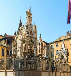 Just close to Piazza dei Signori, on the side of the Palazzo del Capitanio the small church of Santa Maria Antica overlooks a small open space, this was the Scaligeri family chapel. The Romanesque-style church, built in the year 1185 on the ruins of a previous VII century Lombard chapel, has walls with alternating terracotta and tuff ashlars. The monumental burials of the lords of Verona, the so-called Scaliger Arks, were placed behind the church in the 14th century. The most monumental are those of Cangrande I, located above the entrance of the church, that of Mastino I and the hexagonal one of Cansignorio.
Along the road that runs alongside the Arks, there is a building dating from the 13th-14th century, externally well preserved, which well represents the typical fortified home of the most important families of the city during the late Communal age. Considering it the home of Shakespearean Romeo is a suggestive invention inspired by the fact that the Montecchi family, which existed, had its residence in this district of Verona.
After seeing Romeo’s house only externally, it is necessary to visit the much more crowded Juliet’s house. You go back to Piazza dei Signori and then from Piazza Erbe you head south-east along the route of the Cardo Massimo of the Roman urban layout. About seventy meters from Piazza delle Erbe, on the left, there is a tower house dating back to the 13th century. On the arch overlooking the central courtyard, the discovery of a keystone decorated with a bas-relief depicting a hat suggested that this building may have belonged to the Cappelletti family (Shakespearean Capuleti). In the thirties of the 20th century, imaginative restorations redesigned the buildings that overlooked the courtyard, transforming them into the setting of the famous balcony.
Continuing along the Cardo Massimo you reach the remains of Porta Leoni. It was the ancient urban gate built in the middle of the 1st century B.C. together with Porta Borsari. Only part of one of the two internal arches remains of the original structure, while only some parts of the foundations remain of the rest of the building. The original door was in brick and limestone and had two double-arched facades, on the external side it was protected by polygonal towers. During the first imperial period, in conjunction with the construction of the amphitheatre, the doors were restored by placing facades in white stone from Valpantena before the old brick facades.
Continue until you reach the Adige river at the height of the Navi bridge, go up along Lungo Adige up to the New bridge, after which you take via Sottoriva. This street with its characteristic medieval look due to the presence of a low portico is much less crowded than the main streets in the historic centre. In the Middle Ages, the road was inhabited by fishermen and millers, given the numerous mills that crowded the river bank at the time.
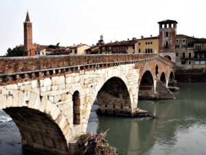 Then you have to walk to reach Ponte Pietra is the oldest bridge in Verona. This bridge was built in the 1st century BC at the narrowest point of the course of the Adige where, after the wide bend of the river, the current is less impetuous. The two white stone arches on the side facing the countryside are the remains of the original structure. Via Postumia passed through Ponte Pietra and the fact that the bridge is not aligned with the layout of the Roman roads makes it possible to hypothesize a construction before the transfer of the inhabited area within the Adige loop. Over the centuries the bridge has undergone various collapses, restoration and rebuilding. In the municipal era, a tower was built on the city side which was then reinforced during the government of Alberto Della Scala, when the adjacent arch was also rebuilt and a second tower was added on the opposite side. At the beginning of the 16th century, the two central arches that had previously collapsed and were replaced for many years by a wooden structure were rebuilt. The last destruction of Ponte Pietra dates back to World War II when the retreating German army blew it up. It was rebuilt between ’57 and ’59 with both the original material and with additions of recycled material coming from the townhouses destroyed by the bombings, trying to respect the previous structure. A little further down, another bridge was built in late roman republican times, aligned with the decumanus maximus. Of this bridge, called Ponte Marmoreo, it means marble bridge, we have only traces of the foundations, having been already destroyed in medieval times.
After crossing the Adige, on the left, you can see the church of Santo Stefano, one of the oldest religious buildings in Verona. The southern wall of this church may date back to the original 5th-century structure. Particular in this church is the octagonal tiburium built perhaps in the first half of the 14th century following typical Lombard and Milanese models: this fact that can lead to hypothesizing its construction towards the end of the same century, during the Visconti intervention on the nearby San Pietro hill that you will reach using the cable car that starts right in the square behind the apse.
The area of San Pietro hill is the area of the first human settlements in the Verona area. After the foundation of the Roman city in the flat area, it was used for the construction of public and religious buildings: the theatre and the Odeon along the hilly slopes overlooking the river and a temple at its top. In the Odeon Teodorico area, he built his palace and not far away, in the valley to the east of the hill, a fortified castrum that perhaps also included the fortification of the upper part of the hill. This fortification was reinforced during the Scala period in part because it was interested in the expansion of the city walls, which was taking place between the end of the 13th and beginning of the 14th century. Further consolidation of the castle by Cangrande II is also hypothesized during the convulsive and violent final stages of the lordship, in conjunction with the construction of the fortress of Castelvecchio.
During the Visconti domination of the end of the 14th century, the fortress on the San Pietro hill was rebuilt cancelling the previous phases. During the Venetian period, the Visconteo castle became the seat of the military commander and accommodation for the garrison stationed in Verona. In 1801 the French almost destroyed the castle. The building that today dominates Verona dates back to the fifties of the 19th century when the Austrians decided to build a barracks on the foundations of the side of the castle facing the city. From the terrace of Castel San Pietro you can enjoy a beautiful view of Verona.
Descending from Castel San Pietro, cross the Adige over Ponte Pietra and return towards via Sottoriva, at the beginning of which you turn right along the Basilica of Santa Anastasia. This church was part of a Dominican monastic complex. The building was started in 1290 and was consecrated almost two centuries later in 1471 and it is the most valuable example of Gothic architecture in the city. The construction of the basilica began thanks to the rich donations of the most important families of Verona, including the Della Scala. An important patron was also Guglielmo of Castelbarco, a friend of Cangrande I, who was also Podestà. In his will, he asked to be buried near the Basilica, and still today it is possible to admire his monument, a funerary ark placed to the left of the facade of the church above the portico that led to the interior of the monastery.
From the basilica, take Corso Sant’Anastasia which then becomes Corso Porta Borsari, another shopping street in Verona, which follows the route of the decumanus maximus of the Roman city.
After passing Piazza delle Erbe, on the right, there is a street surmounted by an arch leading to the Corte delle Sgarzerie. This area of the city was reorganized during the Scaliger lordship and adapted to accommodate the local textile factories. At the centre of the courtyard stands the Loggia del Mangano built in the 14th century, probably part of the so-called “Fondaco del Segnoro”, a series of structures hosting the functionaries responsible for checking the quality of the fabrics. Below Corte delle Sgarzerie, a series of archaeological excavations have brought to light part of the cryptoporticus that surrounded the Capitoline Temple in Roman times.
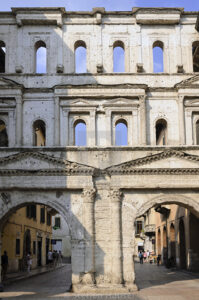 At the end of Corso Porta Borsari you will find the ancient roman gate named Porta Borsari that was built in the second half of the 1st century B.C. in stone and brick and then covered externally by a monumental facade in white stone in the first half of the 1st century A.D. The gate, at that time, was like a small fortress with two external towers one on each side of the gate ad a small court to control the people entering the town. The gate, which in Roman times was called Porta Iovia, was the main entrance to the city since via Postumia passed through it. In medieval times, it was called Porta Borsari as it was the place where the city debt collectors (Bursarii precisely) collected duties. On the false architraves of the shrines that frame the two entrance arches, there is the inscription testifying the restoration and enlargement of the walls made by the emperor Gallienus in 265 A.D.
Just outside Porta Borsari, there are two noteworthy religious buildings. The first is the church of Sante Teuteria and Tosca, at the bottom of Piazzetta Santi Apostoli. It is the oldest church preserved in the Veneto region, although with subsequent alterations. It was consecrated in 751, but perhaps it can be traced back to the 6th century and was certainly built on the remains of a previous Roman building from the 4th century, perhaps a mausoleum. The plan, initially a Greek cross, in medieval times was transformed into a Latin cross. Restorations of the 20th century have restored its early Christian simplicity. Continuing towards Castelvecchio, a little further on the right there is a pink Verona marble arch surmounted by a statue of San Lorenzo which gives access to the basilica same-named. The original early Christian church was destroyed by the earthquake of 1117 and was rebuilt in a Burgundian style with the facade framed by two towers following the model of the church of the Abbey of Cluny. At the end of the 12th century, Pope Lucius III who had established his seat in Verona granted this basilica the same privileges as the Basilica of San Lorenzo fuori le mura in Rome.
The last Roman monument we encounter on our walk is the Gavi monumental arch. This celebratory arch of Gens Gavia, an important family of Roman Verona during the first century A.D., was built outside the city, probably on the edge of Pomerium in the place where Via Postumia and Via Gallica crossed. In the Communal era, it was integrated into the new southern city walls becoming one of the entrance gates to the city, and then, during the Scaliger lordship with the expansion of the city wall, it became part of the fortified system of Castelvecchio. Incorporated in a series of private buildings, during the 16th century it was brought to light by the owners of the time who freed it of all subsequent over-constructions. In 1812 it was dismantled by the Napoleonic military genius and restored in 1932 in Piazzetta Castelvecchio where it can now be admired. Along Corso Castelvecchio, at the height of the Scaliger Bridge, the original location of the arch is highlighted with white stone pavement.
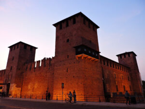 Then you can visit Castelvecchio. The construction of this fortified complex began in 1354 on the order of Cangrande II della Scala, originally the name was Castello di San Martino in Aquaro and took the name of Castel Vecchio (Old Castle) when the Visconti of Milan, after conquering Verona at the end of 14th century, had erected the castles of San Pietro and San Felice. The castle was built to strengthen the defences of the south-western corner of the city but also to give a fortified seat to the lord of Verona given the not very favourable internal political situation. The building straddles the old city wall near the city gates under the Gavi arch. Between the city walls and the Adigetto canal were obtained the courtyard of the palace with the Scaliger residence and the central courtyard with the keep, that was an observation and a defence point connected with the left bank of the Adige through the construction of a fortified bridge with three arches. To the north of the city walls, the large arms court was built for the quartering of troops.
During the Visconti domination, it became an urban fortress closely connected with the fortified area of the citadel through a covered road along the city walls which were also equipped with second battlements along the internal side. During the Venetian lordship, the area of the palace first became the headquarters of officials and then the seat of the military college of the military genius, while the area of the arms court was used as a warehouse and powder keg for artillery. During the Napoleonic occupation, the side of the arms court facing the Adige was demolished and rebuilt to obtain covered artillery positions. The Austrians maintained the Napoleonic structure and used Castelvecchio as an urban barracks. The transformation of the barracks into a museum began in 1920. Today’s installation is due to the restoration and transformation that took place from 1958 to 1974 under the direction of the architect Carlo Scarpa.
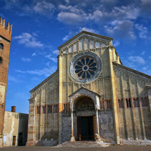 The last stop of your walk is the Basilica of San Zeno Maggiore, one of the most important Romanesque masterpieces in northern Italy. San Zeno was the eighth bishop of Verona who died in the second half of the fourth century. As early as the 5th or 6th century, a church was erected near the tomb. Some fragments carved in Byzantine style reused in later reconstructions suggest a construction phase to be dated to the reign of Theodoric who, as we know, had chosen Verona as his second royal seat. The building was probably renewed during the reign of Desiderio in the 8th century. At the end of the Lombard reign, the church was damaged and the connected monastery set on fire. The Frankish king of Italy Pippin together with Bishop Ratoldo decided that this church was no longer suitable for the conservation of the saint’s relics and therefore built a new one with a crypt, which was consecrated on 8 December 806. During the various raids by the Hungarians, that persecuted this area of Italy during the first half of the 10th century, the basilica, which at the time was outside the city walls, was destroyed. It was rebuilt by Bishop Raterio thanks to the contribution of Emperor Ottone I in the second half of the 10th century. From documents dating back to 1014, we know that the saint’s remains had already been moved to the new basilica. Evidence of this first Romanesque basilica can be seen in the brick wall portions present externally in the area of the right apse. The construction of the bell tower began in 1045. Between the end of the 11th and the beginning of the 12th century, a great project for the enlargement of the basilica was started with the extension of a span, the remaking of the facade and with sidewalls in tuff with projecting pilasters, a gallery with arches with twin columns and arched cornice, this part is still visible on the right side of the basilica. This work should have continued with the reconstruction of all the sidewalls, but after the earthquake of 1117, with the collapse of numerous buildings in Verona, they decided to carry out the work already undertaken but with more modest claims. The walls were then rebuilt more simply by adopting the typical Romanesque style with alternating blocks in tuff and brick. The construction of the new cloister was completed in 1123 (the current cloister is due to a rearrangement done between 1293 and 1313) while in 1138 most of the enlargement of the church was completed and the entrance porch was added. The defensive tower of the abbey was built in 1145 and the bell tower was completed in 1173. The large rose window was built between the last decade of the 12th and the beginning of the 13th century. The last main intervention on the external structure of the basilica took place between 1386 and 1398 when the architect Giovanni da Ferrara transformed the main apse which was still that of the reconstruction of Raterio of the 10th century. In the following centuries, there were further modifications and rearrangements of the internal structure without however upsetting too much the original 12th-century layout.
Among the numerous works of art that we find in the basilica, the prostyle with the 18 high-reliefs of the early 12th century, the larch wood portal with bronze tiles also dating from the same period, but perhaps some tiles date back to the previous one of the late 10th early 11th century, the numerous frescoes, mostly from the 14th century, and finally the Pala di San Zeno masterpiece by Andrea Mantegna dated between 1456 and 1459.